


Join thousands of book lovers
Sign up to our newsletter and receive discounts and inspiration for your next reading experience.
By signing up, you agree to our Privacy Policy.You can, at any time, unsubscribe from our newsletters.
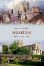
The importance of the attractive town of Hexham began when St Wifrid built his great monastery there in the 7th Century, of which only the unique crypt remains beneath the Priory church. It was bounded by a wall that separated it from the Market Place and the civil administration, which includes the Moothall and Old Gaol. These areas still form the nucleus of the town, which lay in the turbulent Border country between England and Scotland. The vital industry of tanning and glove-making has now gone, but there are smaller industries in its place. The town is a focus of music, the arts and sport. The Queen's Hall houses library, cafe, galleries and theatre. It is linked by roads and by the early Carlisle-Newcastle railway which bring in tourists and local people for many activities such as the Hexham Gathering and the Abbey Arts Festival. Much has changed, but the historic centre remains intact. The author has lived here for over 30 years and is an Honorary Steward and Bailiff of the town.
Felixstowe owes its existence to the 19th-century fashion for seaside holidays when the gentry and businessmen chose to build their summer residences in the parishes of Walton and Felixstowe. In earlier centuries Walton had been the more significant settlement, with a manor and a castle. Even the later fort guarding the Suffolk side of Harwich harbour was often considered to be part of Essex. When the Dutch landed on the Common in 1667 and were defeated by Land guard Fort's garrison, all England heard of the place and King Charles II himself paid them a visit. Join Mike Rouse on this fascinating visual journey around this popular and colourful town, as he shows us what affect history has had on the area through time. This new collection of photographs, carefully selected by the author, is sure to surprise and delight residents and visitors alike.
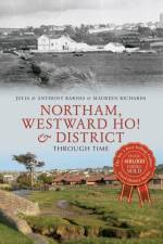
The Manor of Northam dates back to the Norman invasion and is well recorded in the Domesday Book, being part of lands owned by a Saxon Lord called Bristric, and this appears to be the first recorded evidence of what was in the area. There is evidence of prehistoric settlements and much evidence during the Saxon era, when Vikings raided the area. Westward Ho! has its drowned forest and Stone Age kitchen midden hidden beneath the sands, where the sea still exposes deer antlers, flints and ancient pottery. A late Victorian venture with its pier and its palm trees and its grand hotels, it was intended as a holiday resort to challenge Torquay. The surrounding parish, containing about 2700 acres of land, is also included.
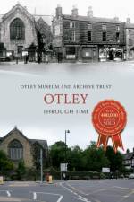
From its beginnings as an Anglo-Saxon settlement, through its development as an agricultural centre with all its related trades and services, the market town of Otley has seen many changes. The invention of Otley's world-famous Wharfedale printing machine contributed to the development of Otley's printing and engineering industry. The railway arrived in 1865, terraced houses replaced thatched cottages and unpaved thoroughfares gave way to tarmac. Today, such changes continue. The railway and most of the factories have disappeared but Otley has retained its popular market town character. The medieval bridge, the twelfth-century parish church and the medieval Kirkgate street plan still serve the townspeople. The selection of photographs in this book show the present alongside the intriguing past, taking readers on a trip around the historic streets of Otley.
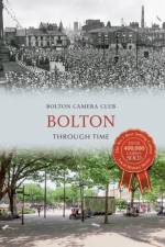
Bolton's name suggests a Saxon origin, and by the twelfth century the local economy was centred on textiles and agriculture. Spinning cotton was the reason for Bolton's rapid expansion during the Industrial Revolution. The nineteenth century witnessed burgeoning growth that brought both prosperity and privation. The twentieth century saw the town coming to terms with this growth and the inevitable further changes that followed. Bolton Through Time provides a pictorial record of some of these changes, comparing historic photographs with their modern counterparts. Readers will see how the modern metropolitan borough compares with its former self - less industrialised and hard edged perhaps, but altogether a greener and more sanitary place. It's a 'must have' for all those interested in Bolton's fascinating history.
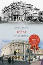
Derby is an exceptional and underrated city. It was an important centre of the Midlands Enlightenment, boasting Dr Erasmus Darwin and John Whitehurst FRS among its eighteenth-century residents. It produced an artist of international repute in Joseph Wright ARA and has been a centre for the production of fine porcelain and fine clocks for almost three centuries. It was a county town for five centuries and was in its Georgian heyday much admired by writers such as Daniel Defoe. Despite the best endeavours of a peculiarly unappreciative and iconoclastic bunch of city fathers over the years, many of its fine Georgian and Regency features have managed to survive. In 90 pairs of photographs ranging from 1765 to the present, Maxwell Craven has attempted to show why it is still a city of which its citizens can be proud and how it has changed, in places out of all recognition.
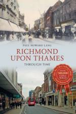
Richmond upon Thames was the first borough to be known as the 'Queen of the Suburbs', before Ealing or Surbiton were known by this sobriquet. With around 100 parks and green spaces, including Kew Gardens and Richmond Park, as well as fine examples of Tudor, Regency, Georgian and Victorian architecture, Richmond remains a desirable place to live, with a long and interesting history. In Richmond upon Thames Through Time, author Paul Howard Lang hopes to show how Richmond, to a great extent, has retained the 'Queen of the Suburbs' title. Telling the story of Richmond and its environs through a selection of beautiful photographs and postcards, he showcases the many changes that have taken place over time, as well as what has remained the same. This is an essential volume for anybody who is familiar with this attractive, historic town.
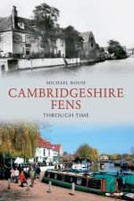
This fascinating selection of photographs traces some of the many ways in which the Cambridgeshire Fens have changed and developed over the last century
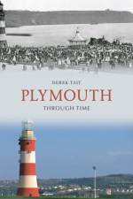
Very few buildings that stood in the centre of Plymouth before the War still remain. The city was devastated by enemy bombing especially during 1941. Many of the old, narrow, congested streets were destroyed completely, changing the face of Plymouth forever. After the War, a new modern City Centre was built with first class stores and spacious streets. Vast changes have also occurred in the areas surrounding the centre. Some areas are now totally unrecognizable but often a bit of old wall, post or fence will be exactly the same as it was a hundred years ago making it easier to work out where an old building, factory or farmhouse might have once stood. This book will prove appealing to both people who are interested in the history of the city and also to those who are interested in how the area has changed over the years.
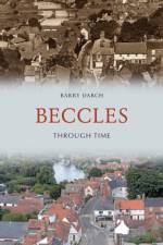
This fascinating selection of photographs shows how Beccles has changed and developed over the last century.
A fascinating collection of images showing how the towns and villages in the Staffordshire Potteries have changed across the last century.
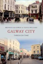
This fascinating selection of photographs traces some of the many ways in which Galway City has changed and developed over the last century.
This book takes a photographic tour of one of the City of Westminster's more distinctive areas, and with a wealth of archive images set alongside comparison photographs from the present day shows how old neighbourhoods have evolved through the decades. Along the way are the carefully preserved Victorian streets of Pimlico's early development and some of the grittier byways which have yielded to war damage and great modern housing estates. The pages are filled with pubs and local traders together with canal and Thames side industry. The local transportation is represented by images of vintage buses and antiquated trams alongside the great transport interchanges which characterise northern Pimlico. Pimlico Through Time offers a fresh look at a much loved London area and will delight and intrigue local residents and visitors alike.
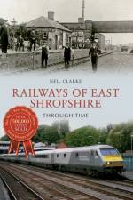
The history of East Shropshire has had a global impact, with Ironbridge and Coalbrookdale acknowledged as the 'Cradle of the Industrial Revolution'. In this book, local industrial history expert Neil Clarke examines through photographs the history of the railways in this area, which both came from the Industrial Revolution and enabled its growth, through the rapid expansion of the nineteenth century and the Grouping and the Beeching Axe of the twentieth century to the present day. Everything, from the first wagonways (early railways) to individual branch lines of the area, is examined using both old photographs and drawings and modern photographs to show the development of railways in the area. This area of Shropshire has changed beyond all recognition, as the harsh lines of industry have been replaced with greenery, yet the remnants of its industrial past can still be seen, especially through its railways.
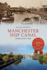
The Manchester Ship Canal was a huge engineering achievement. It included seven swing bridges and the aqueduct at Barton, and helped turn the cotton-producing capital of Great Britain into an inland seaport. This was a feat many at the time believed could not be achieved. One of the wonders of the modern industrial world, the Manchester Ship Canal, with its huge locks and ocean-going vessels, was a magnetic draw for enthusiastic Victorians who marvelled at its construction. This book looks at the changes and development of the Manchester Ship Canal through time, from its origins as a thriving economic hub in the late nineteenth century, to an important retail, leisure and media centre in the early twenty-first century and beyond. Join Steven Dickens as he explores the history of this 36-mile-long inland waterway in the north-west of England, which links Manchester to the Mersey Estuary and the Irish Sea.
This fascinating selection of photographs traces some of the many ways in which Liverpool has changed and developed over the last century.
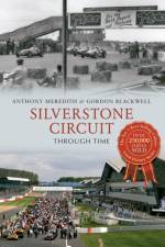
With the liberal use of many previously unpublished photographs contrasting past and present, Silverstone Circuit Through Time shows how a wartime airfield developed, stage by stage, into the country's premier motor racing circuit, the annual home of Formula One's spectacular British Grand Prix. Though touching on some of the great personalities associated with the place, it is essentially a book about the circuit itself. There is much nostalgic emphasis on the 1950s and 1960s, when love of the sport and a willingness to make the best of things had to compensate for the somewhat primitive facilities on offer. The remarkable turnaround of more recent years is also fully explored, as a fairly ramshackle venue reflecting the dreamy surrounding countryside turned itself into a high-tech entertainment centre bristling with ambition for the future.
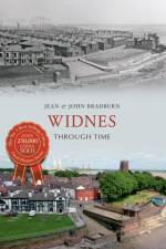
Widnes is an industrial town within the borough of Halton, in the ceremonial county of Cheshire, England, with an urban area population of 57,663 in 2004. It is located on the northern bank of the River Mersey where the estuary narrows to form Runcorn Gap. Directly to the south of Widnes across the Mersey is the town of Runcorn. Upstream and 8 miles to the east of Widnes is the town of Warrington, and downstream 16 miles to the west is the city of Liverpool. Historically part of Lancashire, prior to the Industrial Revolution Widnes consisted of a small number of separate settlements on land which was mainly marsh or moorland. In 1847 the first chemical factory was established and the town rapidly became a major centre of the chemical industry. Widnes continues to be a major manufacturer of chemicals and there has been a degree of diversification of the town's industries. Widnes lies on the southern route of the Liverpool to Manchester railway line. The Sankey Canal (now disused) terminates in an area of Widnes known as Spike Island.
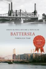
Battersea has grown to be a fashionable and vibrant district of south-west London. Referred to as Patricesy in the Domesday Book, Battersea was historically best known for market gardening, providing fruit, vegetables and flowers for the City of London. However, the area moved from rural to urban with the coming of the railways, industry and large-scale housing from the 1840s, provoking a population growth from 4,000 to 120,000 by the beginning of the twentieth century. Glimpses of the past can still be seen around modern Battersea, but much has changed over the years. Using a selection of old and new photographs, local historians Simon McNeill-Ritchie and Ron Elam trace Battersea's unique journey over the past century. Featuring landmarks such as Battersea Power Station, Battersea Dogs & Cats Home and Battersea Park, this book is essential reading for anyone who knows and loves this famous South London district.
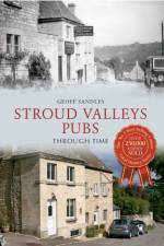
Stroud is the capital of the south-western Cotswolds, located at the divergence of the five Golden Valleys, named after the monetary wealth created in the processing of wool from the plentiful supply of water power. Five populated valleys converge at Stroud, ten miles south-west of Cheltenham, creating a bustle of hills. The bustle is not a new phenomenon. During the heyday of the wool trade the River Frome powered 150 mills, creating thirsty workers in need of refreshment. In this the fifth of his series of Pubs Through Time, Geoff Sandles takes us on an affectionate visual journey through the valleys' watering holes, and uses old and new images, as well as entertaining captions to bring the history of the Stroud Valleys' pubs to life. From Amberley to Woodchester, Stroud Valleys Pubs Through Time will delight and surprise those who regularly frequent these establishments and know the area well.
Sign up to our newsletter and receive discounts and inspiration for your next reading experience.
By signing up, you agree to our Privacy Policy.