
Join thousands of book lovers
Sign up to our newsletter and receive discounts and inspiration for your next reading experience.
By signing up, you agree to our Privacy Policy.You can, at any time, unsubscribe from our newsletters.
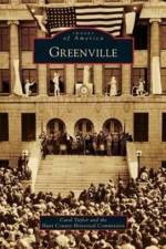
Located on the rolling Blackland Prairies of Northeast Texas, Greenville was founded in January 1847 as the county seat of Hunt County. Through the years, it became not only the seat of local and county government, but the economic, social, and cultural center of much of the area. With the arrival of the railroads in 1880, Greenville became a market center for cotton, livestock, and other agricultural products, and a vast assortment of goods were available to discerning shoppers. Paved roads, a professional theater, baseball, football, and the North Texas Fair brought visitors to Greenville from the surrounding areas. Merchants, bankers, and entrepreneurs worked diligently to create a community of modern conveniences, beautiful homes, churches, and schools. One of the first municipally owned power plants opened in Greenville in the late 19th century. Though they do keep up with the times, Greenville residents continue to honor their town's remarkable history.
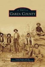
Garza County was created in 1876 and named by Texas legislators in honor of the de la Garza family of San Antonio. The county lay claim to vast ranch lands with the picturesque cap rock escarpment weaving its way from north to south. Though the 1880 census listed the population as a sparse 36 people--mostly landowners and cowhands--cattlemen like John B. Slaughter and W. E. Connell owned massive spreads in excess of 100,000 acres with more than 5,000 head of cattle and 100 horses. By 1900, the population had grown to 180, with only 545 acres in cultivation. Things changed with the arrival of cereal magnate C. W. Post, who came to Garza County to begin building his model town and experimental farming campaign. On June 15, 1907, an election to organize the county was held and Post City became the official county seat, touting the slogan "Gateway to the Plains."
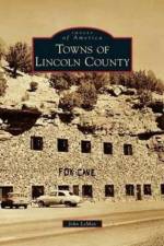
Lincoln County is often associated with such legendary figures as outlaw Billy the Kid, Smokey the Bear, and renowned painter Peter Hurd. Named after Pres. Abraham Lincoln in 1869, the new county saw itself through many struggles, including the Lincoln County War, during which cattle barons and landowners bitterly fought over government beef contracts and farmland. At that time, Lincoln was the largest county in the United States and is now home to modern mountain towns such as Carrizozo, Capitan, Ruidoso, and the locally famous ghost town White Oaks, which had been a gold rush boomtown. Lincoln County also contains the beautiful Hondo Valley settlements and ranching communities such as Tinnie, Picacho, San Patricio, Hondo, and Glencoe. From the rolling hills of the Hondo Valley, to the bloody streets of Lincoln, all the way to the forested mountains of Capitan, this retrospective explores the area's rich history.
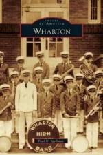
On a bend in the Colorado River where it meanders through the Bay Prairie lies the town of Wharton. Caney and Peach Creeks spill into the river nearby and mark the boundaries of this small community. Stephen F. Austin first brought settlers here in the early 1820s, and the town of Wharton was organized in 1846. Named in memory of two brothers who fought in the Texas Revolution, the town sits astride trade routes that connect larger cities like Houston and San Antonio. Steamboats made their way up the Colorado River, and the railroad bustled through in the 1880s. The town began to grow quickly by 1900, and now, a century later, Wharton honors a diverse cultural heritage passed down for six generations. Today Wharton has more than 9,000 residents who make up a diverse and thriving community, and who still appreciate their special place along the mighty Colorado River.
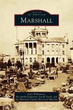
Nestled among towering pine trees in East Texas is the city of Marshall. Marshall is closely identified with Caddo Lake, a massive body of water located northeast of the town. According to the Caddo Indians who first inhabited this land, the mysterious lake was formed overnight from an earthquake. Spanish and French explorers sought to claim the land as their own in the 16th century, and American settlers arrived here in about 1830. The city of Marshall was founded in 1842, eventually becoming the county seat of Harrison County. With the arrival of the Texas and Pacific Railroad after the Civil War, Marshall became known as the "Gateway to Texas," and the town prospered. Today education plays an important role in the local economy, and Marshall is the home of Wiley College, East Texas Baptist University, and Texas State Technical Institute. Life in Marshall continues to revolve around the town square, with the majestic, restored courthouse at its center.
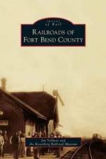
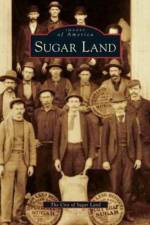
Fort Bend County was formed in the early 1820s by members of Stephen F. Austin's "Old 300." Traders utilized barges and steamboats running along the Brazos River to transport cotton and other products from the lower Brazos Valley to the port at Galveston. In 1853, railroads began to play a larger role in the county's transportation system. Transportation facilities were greatly improved when the first railroad in Texas, the Buffalo, Brazos, and Colorado Railroad Company, completed its first 20-mile segment to Stafford's Point in Fort Bend County from Harrisburg (Houston). As many as eight separate railroads were chartered and operated in Fort Bend County by 1900. Today some of the names have changed but most of the original rail lines remain in operation. The Union Pacific, Burlington Northern Santa Fe, and Kansas City Southern rail companies have picked up where their predecessors left off and are keeping Fort Bend County one of the busiest and fastest-growing counties in the United States.
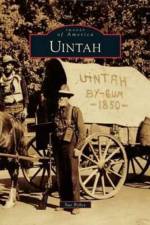
Nestled at the foot of the Wasatch Mountains is a small community with a grand history. The area's first inhabitants were Native Americans until eight Mormon families arrived in 1850. With the coming of the railroad in 1869, Uintah quickly became a wild and woolly boomtown with more than 100 businesses and a population of about 5,000. But when the Utah Central Railroad moved to Ogden, many people moved out of Uintah. Still, this spirited town has survived, and every year, U-Day celebrates the history of the town with various events and the lighting of the historic "U." Originally built by Uintah residents and located on the northern side of Weber Canyon, the "U" is a meaningful symbol of Uintah's past and present. To this day, Uintah retains its small-town character, and residents honor the history of their town.
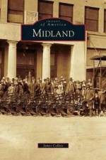
Midland was a young farming and ranching community on the southern edge of the Llano Estacado when the real-photo postcard era began near the opening of the 20th century. Businesses, residents, and promoters embraced this new technology to produce images capturing Midland's unusual rural-and-cosmopolitan mix. As postcards changed to linen and chrome, Midland also underwent dramatic changes. The city on the plains worked hard to become an indispensable part of the vast 1920s Permian Basin oil industry. In post-World War II years, Midland grew into an urban center of West Texas, positioned strategically at the midpoint of Interstate 20's path from Fort Worth to El Paso.
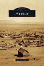
"Alpine was born a railroad town, but long before the whistle of the steam locomotive broke the silence of Alpine Valley, the nearby spring was a favored campground for prehistoric nomads and later for Spanish explorers and freighters along the Chihuahua Trail. When the Southern Pacific unfurled its line down from Paisano Pass in 1882, landowner Thomas Murphy saw opportunity and platted the town. In 1887, Alpine was chosen as the county seat, and with the opening of Sul Ross Normal College in 1920, the town became the academic hub of the region. Following a decade of prosperity, the Great Depression and recurrent droughts triggered a slow decline. But since the early 1990s, Alpine has enjoyed a surge in regional art and culture, allowing it to reclaim its former glory as a proud little cosmopolitan cowtown perched at the top of the Texas Big Bend"--Provided by publisher.
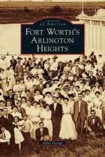
On the prairie west of Fort Worth, British-born Humphrey Barker Chamberlin commissioned a model mansion, grand hotel, trolley line, lake, and waterworks in the early 1890s. He launched Chamberlin Arlington Heights as an opulent suburb reminiscent of his Capitol Hill enclave in Denver, then lost his overextended empire in the silver panic of 1893. Although several more well-to-do families established homes near those of the original "Heights pioneers," development progressed slowly. With the coming of World War I, local leaders persuaded the U.S. Army to build Camp Bowie across much of the sparsely settled area, providing infrastructure. A bungalow boom followed, with housing additions for the middle class and annexation by Fort Worth. As the 20th century drew to a close, preservationists sought protection for the legacy of built treasures within the neighborhood.
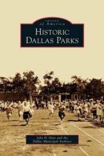
Dallas, called "Big D," is the eighth largest city in the United States and rests on 343 square miles of rolling prairie. To meet the growing recreational and cultural needs of its citizens, the Dallas Park and Recreation Department maintains more than 23,018 park acres--one of the largest municipal park systems in the country. Dallas has over 400 individual parks, including community centers, swimming pools, athletic fields, and a metropolitan zoo. From such well-known places as Fair Park, home of the State Fair of Texas and the Texas Centennial Exposition of 1936, to Dealey Plaza, and to lesser-known neighborhood parks, Dallas parks have a rich history stretching from the days when Dallas was a western boom town to a 21st century metropolis. Historic Dallas Parks explores the origins and early development of this nationally recognized system with interesting background stories and facts and illustrated with photographs and historical documents from the collections of the Dallas Municipal Archives.
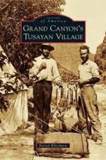
With the glamorous Grand Canyon as its backyard, Tusayan has a fascinating history. Dedicated just one year after the Grand Canyon National Park, the village of Tusayan had its humble beginnings in 1920 as a small sheep ranch operated by the Hull brothers. Tusayan quickly became a hub for the millions of travelers who made their way to the Grand Canyon each year. The two areas share a mutual school, a health care center, and other amenities. Other pioneers, such as R. P. Thurston, helped ensure the area's longevity with the addition of Highway 64 through the center of the village and the arrival of the Grand Canyon Airport, making Tusayan one of the most visited little towns in northern Arizona.
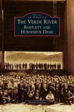
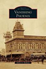
Archaeologists discovered that the Hohokam were an advanced native tribe who built elaborate irrigation systems along the Verde River, and then disappeared. Early Arizona settlers recognized the tenacity and intelligence of the Hohokam and began to reconstruct their canal system. In 1903, the Salt River Project commenced, and the first lake on the lower Verde River was formed with the completion of the Bartlett Dam in 1939. Seven years later and 12 miles upstream from Bartlett, the Horseshoe Reservoir was created in order to expand copper mining during World War II. The astonishing result of these reservoirs is today's sprawling desert megalopolis of Phoenix, Arizona. Nicknamed "The River of Time," the Verde River is a timeline of Arizona history, and it is essential to human life and livelihood in the area.
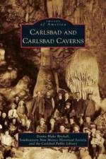
Created by the visionary Charles B. Eddy, Carlsbad rose from the humble beginnings of a tent city to become a vital community on the banks of the Pecos River. One of the largest irrigation projects known at that time made the transformation possible. The Carlsbad Caverns, discovered by James Larkin White and documented by local photographer Ray V. Davis, introduced the world to the wonders that lay beneath the desert surface. World War II saw Carlsbad members of the 200th and 515th Coast Artillery units being thrown into the midst of the Bataan Death March. With the discovery of a large deposit of potash east of town, agriculture flourished nationwide and prosperity returned to the town. As the country moved into the nuclear age, Carlsbad once again played a significant role. The detonation of the Gnome Project in 1961 and the Waste Isolation Pilot Plant of the present day have provided the country with vital knowledge and nuclear waste storage.
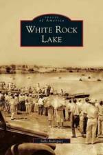
In 1909, Dallas city leaders approved the damming of White Rock Creek to create a new water source for the increasing needs of a growing city. As a result, so much of the life and history of Dallas has echoed through the life and history of White Rock Lake. In the early decades, the lake was home to many private summer homes and boat houses, as well as hunting and fishing clubs. Soon thereafter, a bathing beach, sailing clubs, public boathouses, and picnic facilities were added. The Civilian Conservation Corps and the Works Progress Administration transformed the lake with more recreational and leisure amenities. World War II brought increased military uses that included a POW camp for German officers. Those early city leaders could hardly know that the lake they were creating 10 miles outside of Dallas would become an urban oasis enjoyed by over two million visitors a year.
Includes images from the Arizona State University McLaughlin Collection, the Phoenix Museum of History and private collections.
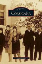
The first Texas legislature created Navarro County in 1846 and named it in honor of Texas patriot Jose Antonio Navarro. When asked to name the new seat of government, Navarro replied, "Call it Corsicana for the island of Corsica, the birthplace of my father." From its beginnings in 1848, Corsicana's history has been marked by Texas icons such as cotton, cattle, and chili. The town's history took a dramatic turn when drillers looking for water struck oil instead in 1894. By the end of the decade, more than 500 wells dotted the landscape, marking the first commercial oil field in Texas and launching the industry that has become synonymous with the Lone Star State. Oil, business enterprises, and politics are important parts of Corsicana's legacy, but much of its history is found in the everyday events that make up the fabric of a community. Local history is filled with stories of people who overcame obstacles to fulfill the American Dream.
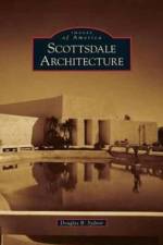
U.S. Army chaplain Winfield Scott and his wife, Helen, founded Scottsdale in 1888 as a small farming and ranching settlement on undeveloped desert east of Phoenix. After World War II, many people were attracted by the dry climate, desert landscape, and business opportunities. The community encouraged creativity in architecture, and Frank Lloyd Wright, Paolo Soleri, and Paul Schweikher designed buildings here. To draw tourists, the business community adopted "The West's Most Western Town" as a slogan in 1947. By the time employers such as Motorola arrived, fast-paced construction was already underway and the architecture reflected that era. In the 1970s, an architectural debate took place between western and modern styles, resulting in innovative architecture. Transitioning into the 21st century, Scottsdale witnessed more growth with downtown revitalization, a new appreciation of contemporary projects, and an awareness of desert preservation.
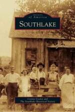
Of the settlers who journeyed to North Texas 165 years ago, 12 families from Missouri traveled in oxen-drawn wagons to the Eastern Cross Timbers. These families laid claim to land in Peters Colony that was promised by the Republic of Texas's first empresario. The hardscrabble colonists built log cabins and the Lonesome Dove Church, the first church in Tarrant County. Their village came to be called Dove. Later settlements included White's Chapel, Old Union, and Jellico. The Depression hit local farmers and cattlemen hard, and newspaper accounts tell of small-time outlaws passing through, including members of the infamous Bonnie and Clyde gang who shot and killed two state troopers near Texas Highway 114. In 1956, a handful of neighbors voted to incorporate, and the town of Southlake was born. A decade later, city leaders from nearby Dallas and Fort Worth agreed to the construction of a regional airport east of Southlake, and the Dallas-Fort Worth Airport brought many families and prosperity to an area that flourishes today.
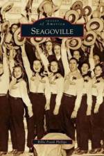
Seagoville was founded in 1879 by T. K. Seago, who also donated the land that brought the Texas and New Orleans Railroad. With the arrival of this new railroad, Seagoville became an industrial frontier. The first church was organized in 1872, and the first bank was founded in 1905. By 1911, the city could boast that there were seven citizens who owned automobiles. Although the Great Depression had its impact, there were no bread lines in town because the local cannery provided employment. The movie actor Chill Wills was born here and went on to star with such noted actors as John Wayne and Spencer Tracy. During World War II, the city sent 228 of its 720 citizens to the armed services. Even today, numerous stories circulate about the infamous Bonnie and Clyde spending time in town.
Sign up to our newsletter and receive discounts and inspiration for your next reading experience.
By signing up, you agree to our Privacy Policy.